
Philippine President Benigno S. Aquino III was one of the world leaders who endorsed The New York Declaration on Forests (NYDF) when it was launched at the United Nations Climate Summit in September 2014 [1]. The NYDF is a non-legally binding political declaration to “cut natural forest loss in half by 2020, and strive to end it by 2030.”
A recent report from Zarin et al. [2], detailed the shared vision of NYDF’s supporters. NYDF hopes to advance the implementation of:
– intergovernmental partnerships to reduce emissions from deforestation and forest degradation, and foster conservation, sustainable management of forests, and enhancement of forest carbon stocks (REDD+) that emerged within the United Nations Framework Convention on Climate Change (UNFCCC);
– corporate commitments to remove deforestation from agricultural commodity supply chains that have been made by large-scale purchasers, traders, and producers of those commodities in response to advocacy campaigns that have influenced consumer-facing brands; and
– land and resource tenure reform efforts that aim to formalize the rights of indigenous and other traditional communities to forests that they have generally sought to protect from encroachment.
Pres. Aquino even delivered a speech during the summit, pointing out the Philippines’ effort in “addressing climate change to the maximum with our limited resources.” He also emphasized the massive re-greening program on top of an intensified anti-illegal logging campaign [3].
Re-greening? So how far is the Philippines in reducing the loss of the country’s ‘greens’?
Let us look at some of the current mapping research results. Few of my friends from the University of Maryland (UMD) Department of Geographical Sciences (considered as #4 in the World for Remote Sensing Research) [4], are involved in mapping the world’s forest covers using satellite images. Satellite imagery is an essential resource for capturing disturbance processes and for the estimation of land cover change [5, 6]. Using the 30-m resolution Landsat in combination with other spatial data layers, a global forest map was created. For more detailed description of the methodology used to create the final data product, refer to Zarin et al. [2].
I took the liberty to summarize the data from the Philippines. Here is the country’s status (via Global Forest Watch):
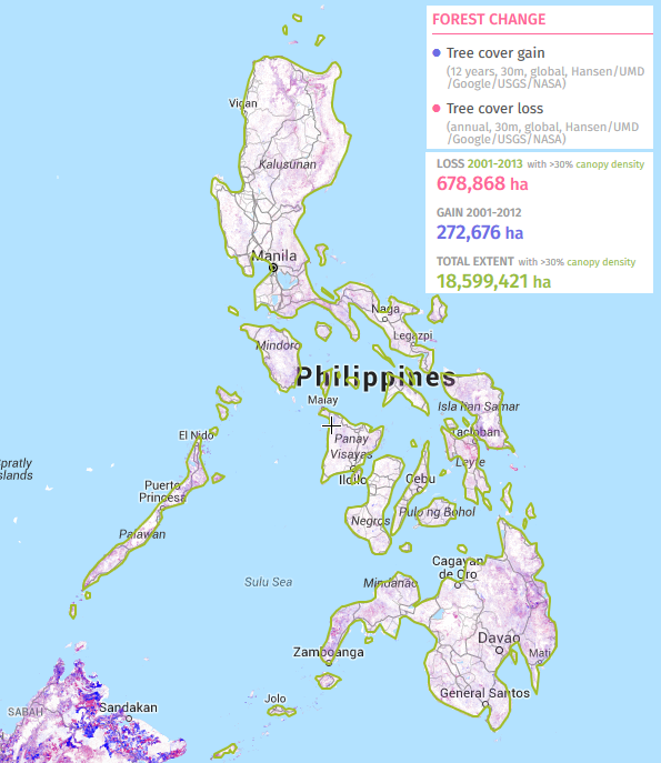
Although the total tree cover gain (272,676 ha) was only analyzed from the 2001 to 2012 period, it was still way less than the total tree cover loss* (678,868 ha from the period 2001 to 2013).
Where is the Philippines in the ranking of countries with the greatest tree cover loss (from 2001-2014)? We are at no. 38 out of 203 nations worldwide (Note: The number of nations was based on the Montevideo Convention). Most Southeast Asian countries are doing worst than us — Indonesia at no. 5, Malaysia at no. 8, Myanmar at no. 18, Laos at no. 24, Cambodia at no. 25, Vietnam at no. 26, and Thailand at no. 29. The no. 1 country with the greatest tree cover loss is Russia, followed by Brazil at no. 2, Canada at no. 3, and the United States at no. 4.
Further, I looked at the numbers at the subnational level by plotting the provinces with the highest average of tree cover loss from 2001 to 2014 (Fig. 2). Which Philippine province is at the top of the list?
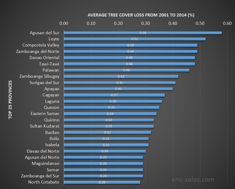
Agusan del Sur tops the list with 0.58% average rate of tree cover loss from 2001 to 2014. Leyte, Compostela Valley, Zamboanga del Norte, Davao Oriental, Tawi-Tawi, Palawan, Zamboanga Sibugay, Surigao del Sur, and Apayao complete the top 10 provinces. Below (Fig. 3) is the plot for the annual gross tree cover loss from 2001 to 2014 for the top ten provinces.
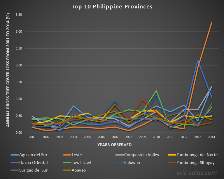
The province of Leyte shows a sudden spike of the trend after 2012. This spike is also evident for Eastern Samar (not shown). The loss of tree cover may be attributed to Typhoon Yolanda (aka Typhoon Haiyan) that devastated the region in November 2013.
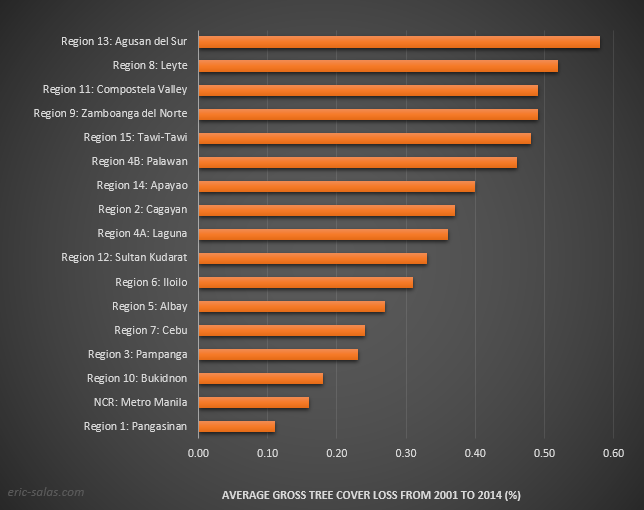
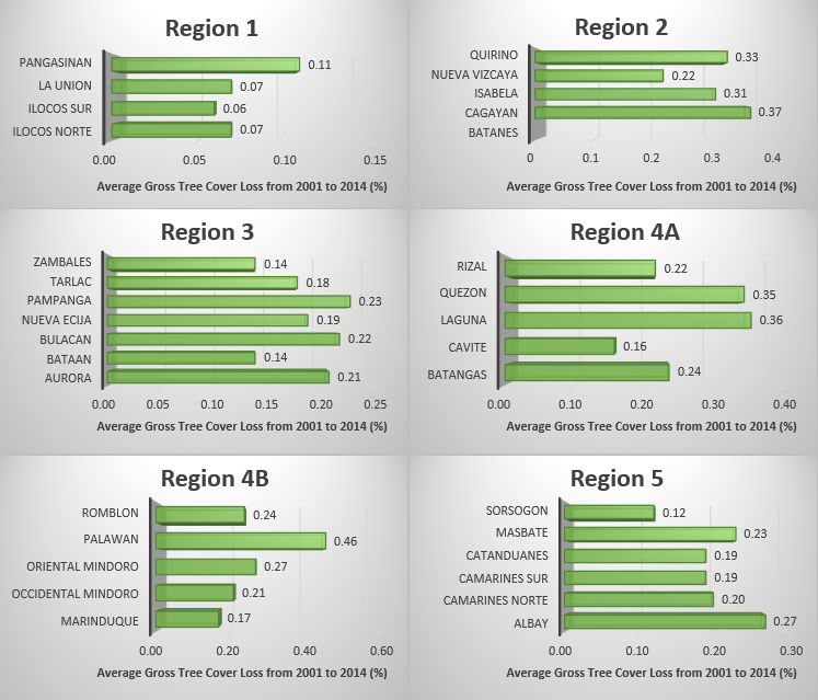
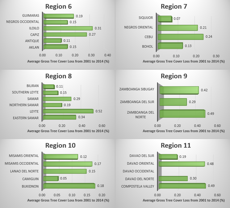
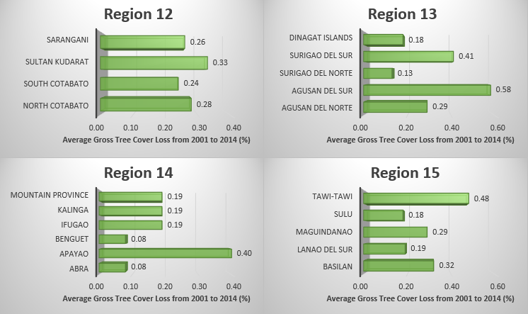
In Fig. 4, I plotted the provinces with the highest rate of tree cover loss per Region. Cebu has the highest rate in Region 7, Palawan in Region 4B, and Iloilo in Region 6.
Averaging the rates of tree cover loss per region, Region 9 comes out with the highest rate of tree cover loss in the country, Region 11 is next, then Region 13 is third (Fig. 5).
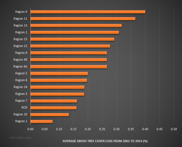
Figure 6 below shows the rates of all the provinces per region.
Why forest and tree cover matter? According to the NYDF [1], they support up to 80% of terrestrial biodiversity and play a vital role in safeguarding the climate by naturally sequestering carbon (CO2). They help remove carbon from the atmosphere by acting as long-term carbon reservoirs.
The U.S. Forest Service explains:
Interest in terrestrial carbon sequestration has increased in an effort to explore opportunities for climate change mitigation. Carbon sequestration is the process by which atmospheric carbon dioxide is taken up by trees, grasses, and other plants through photosynthesis and stored as carbon in biomass (trunks, branches, foliage, and roots) and soils. The sink of carbon sequestration in forests and wood products helps to offset sources of carbon dioxide to the atmosphere, such as deforestation, forest fires, and fossil fuel emissions.
Here is a good discussion of the CO2 emissions due to deforestation or tree cover loss, via The Center for Investigative Reporting:
About one fifth of total global CO2 emissions come from the forest sector, according to the UN’s Intergovernmental Panel on Climate Change. Some of these emissions are due to deforestation, which comes from agricultural activities, biofuel plantations and illegal logging for precious woods such as cedar and mahogany, according to research by Dr. Matthew Finer, an ecologist at Save America’s Forests. Some of these emissions are due to “degradation” which comes from accidental fires or controlled burns, and in some cases, from forest dwellers cutting trees—such as palm—for food.
This is important, because in some developing countries, more carbon emissions come from deforestation than from energy generation, said Florence Daviet, a senior associate at the World Resources Institute’s climate and energy program, in a telephone interview from Copenhagen.
In addition, forestry projects could have a “quite a large impact” on mitigating climate change, said Professor Daniel Kammen, director of the Renewable and Appropriate Energy Laboratory at the University of California, Berkeley, in a telephone interview from Lisbon, Portugal.
“Between 25 to 30 percent of total greenhouse gas emissions come from land-use change, so deforestation counts for significant amount of that change,” he said.
Okay, we have quantified the deforestation rates per province, but how much has the tree cover loss contributed to CO2 emissions in the Philippines?
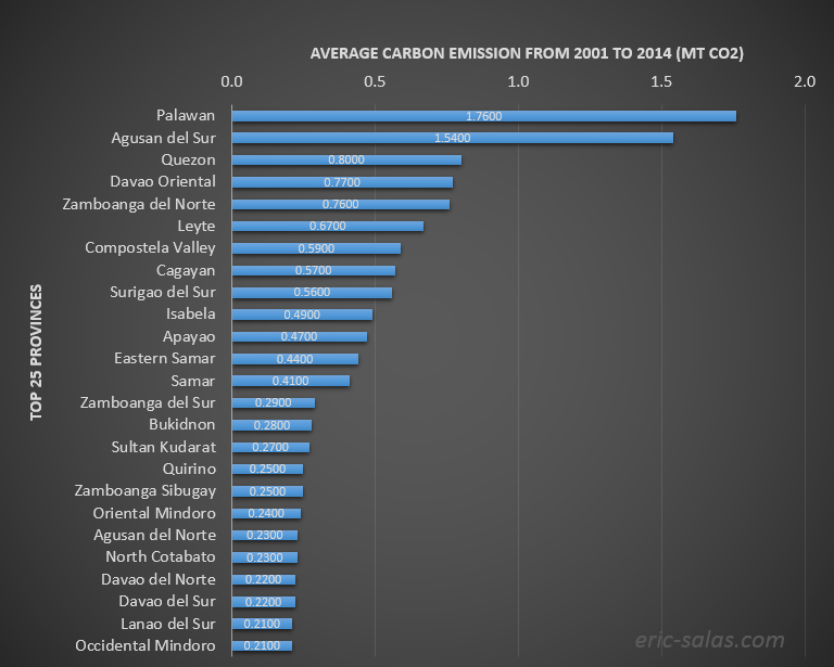
The province of Palawan has the highest average carbon emission (1.76 million tons of CO2) recorded from 2001 to 2014 (Fig. 7).
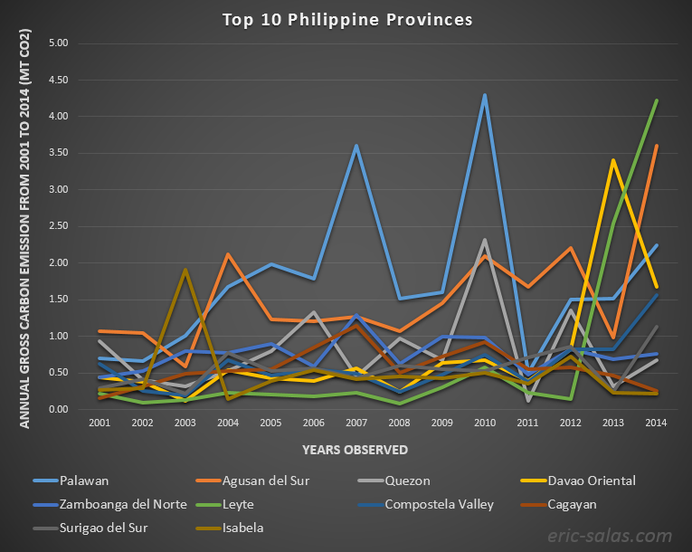
However, Palawan’s emissions in the last three years are actually lower compared to the previous years (Fig. 8). Again, the sudden spike for Leyte is evident after 2012.
And here is the graph of the provinces with the highest carbon emissions for each region.
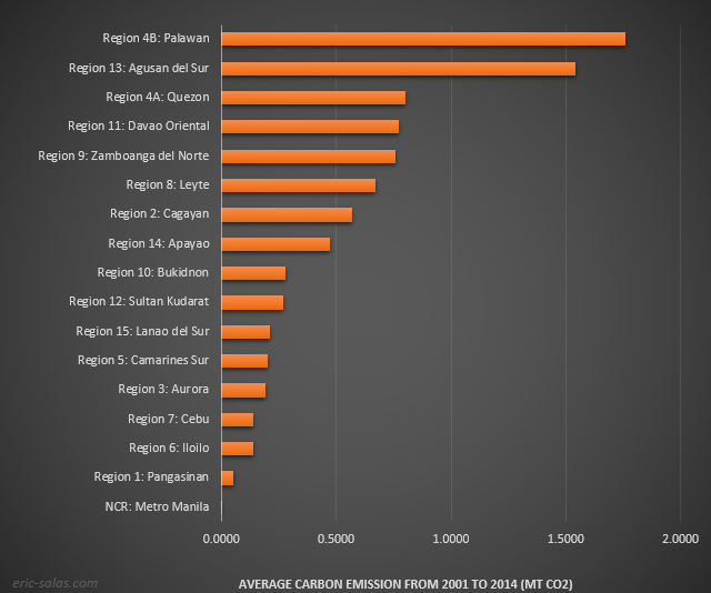
Which region has contributed the most carbon emission in the country? It is Region 13.
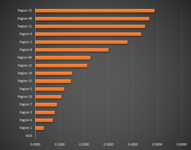
Now go back to Fig. 5 and you see that the provinces with high rates of tree cover loss have also high average of carbon emissions.
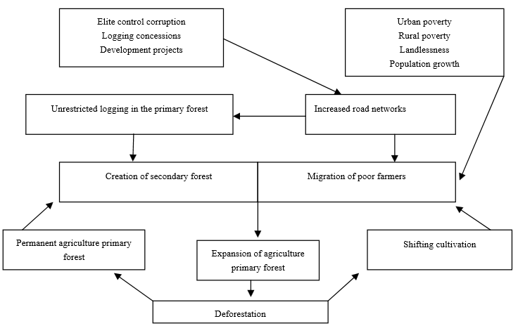
While there may be current efforts to reduce the rate of loss of tree covers in the Philippines, I believe that we still need to push the efforts more forward. A recent paper by Jayagoda [8] published in the Journal of Sustainable Development, cited the reasons for Philippines’ deforestation: shifting cultivation, unorganized encroachment on forest lands, squatting, migration of landless lowlanders into upland forested areas, and government-sponsored settlement schemes (Fig. 11).
The NYDF [1] listed the ways the government can do to reduce deforestation:
– Institute policies to protect and sustainably manage natural forests and shift agricultural expansion to non-forested and degraded lands, while promoting sustainable and equitable development.
– Strengthen implementation and enforcement of legal frameworks for protecting and sustainably managing forests.
– Promote and support participation and respect the rights of indigenous peoples, including to their lands, territories and resources, consistent with applicable law.
– Clarify rights in land tenure systems to improve land security, strengthen community management of natural resources and resolve overlapping forest clearing concessions.
– Provide support to producers, in particular smallholders, to adapt better management practices, comply with relevant policies and increase productivity on existing farms and new non-forested lands.
– Support the development of alternative economic opportunities to those relying on forest loss.
– Use real time satellite imagery and on the ground monitoring to clamp down on illegal deforestation and degradation.
– Promote public procurement systems that favor sustainably sourced commodities, and educate citizens about responsible consumption.
– Stop the importation of illegally sourced commodities.
– Support partner countries, including through development assistance and economic incentives, to undertake policies and measures that help address deforestation.
How much effort do you think will the Philippine government exert in reducing tree cover loss in the country?
***
*Tree cover loss is not always deforestation. An important caveat of the global Hansen et al. [7] tree cover loss data is that the definition of gross tree cover loss includes rotational clear-felling within tree plantations and clearing in shifting cultivation cycles, along with conversion of natural forests. Additional note from the authors: Please also be aware that “tree cover” does not equate to “forest cover.” “Tree cover” refers to the biophysical presence of trees, which may be a part of natural forests or tree plantations. Thus, loss of tree cover may occur for many reasons, including deforestation, fire, and logging within the course of sustainable forestry operations. Similarly, tree cover gain may indicate the growth of tree canopy within natural or managed forests.
For more data explanations and limitations, kindly refer to Hansen et al., Science 2013 [7].
[1] UN Climate Summit, 2014. Download the full report (PDF) here.
[2] Zarin, D. J., Harris, N. L., Baccini, A., Aksenov, D., Hansen, M. C., Ramos, C. A., Azevedo, T., Margono, B. A., Alencar, A. C., Gabris, C., Allegretti, A., Potapov, P., Farina, M., Walker, W. S., Shevade, V. S., Loboda, T. V., Turubanova, S. and Tyukavina, A., 2015. Can carbon emissions from tropical deforestation drop by 50% in five years?. Glob Change Biol. Accepted Author Manuscript. doi:10.1111/gcb.13153
[3] Speech of President Aquino at the UN Climate Change Summit 2014. Link to the full speech.
[4] Zhuang, Y., Liu, X., Nguyen, T., He, Q., & Hong, S. (2013). Global remote sensing research trends during 1991–2010: a bibliometric analysis. Scientometrics, 96, 203-219. Link to the full article.
[5] Sachs, D.L., Sollins, P., Cohen, W.B., 1998. Detecting landscape changes in the interior of British Columbia from 1975–1992 using satellite imagery. Can. J. For. Res., 28, 23–36.
[6] Kennedy, R.E., Cohen, W.B., Schroeder, T.A., 2007. Trajectory-based change detection for automated characterization of forest disturbance dynamics. Remote Sens. Environ., 110, 370 – 386.
[7] Hansen, M. C., P. V. Potapov, R. Moore, M. Hancher, S. A. Turubanova, A. Tyukavina, D. Thau, S. V. Stehman, S. J. Goetz, T. R. Loveland, A. Kommareddy, A. Egorov, L. Chini, C. O. Justice, and J. R. G. Townshend. 2013. “High-Resolution Global Maps of 21st-Century Forest Cover Change.” Science 342 (15 November): 850–53. Data available on-line from: http://earthenginepartners.appspot.com/science-2013-global-forest.
[8] Jayagoda, D.D. 2015. A Unique Case Study of Tree Plantation Bringing Increased Forest Cover to Puerto Princesa, Philippines. Journal of Sustainable Development, Vol. 8, No. 1; 2015.